TECHNOLOGY
MAPPING IN 3D
12 Apr 2010

As digitisation becomes an increasingly ubiquitous feature of the 20th century, PIONEER checks out how the Singapore Armed Forces' (SAF's) Mapping Unit, which turns 40 this year, keeps up with technological changes to provide the SAF with advanced mapping capabilities.
Established in 1970, the SAF Mapping Unit was initially set up to produce topographic maps for military use.
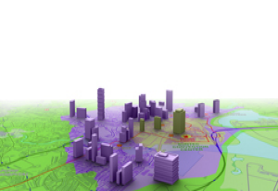
In keeping with today's age of Google Earth and the Global Positioning System (GPS), the unit's capabilities have evolved to include the development of realistic three-dimensional (3D) virtual maps with greater accuracy and efficiency. Producing not just standard maps but also geospatial products that are akin to those provided by today's location-based services such as Ovi (Nokia's brand for its Internet services) maps and Google Maps for the iPhone with a precision that is unmatched.
Want to know the importance of the geospatial information provided by the SAF Mapping Unit? Take a look at these three ways in which their maps have come in handy!
1. Location, location, location
Navigation and risk evaluation
A veteran mapper who has been in the SAF Mapping Unit for almost 40 years, Mr Khoo Puay Jin, a Deputy Branch Head, has seen the unit move from manual plotting machines to high-end digital workstations.
While 3D models are not as portable as paper maps, they enable users to better visualise and familiarise themselves with their area of operations for planning and simulation of mission rehearsals, he said.
The data of these digital maps provides the foundation of precise map coordinates in various command and control systems, and is mainly used for planning and analysis, as well as an aid for navigation. In addition, troops use these maps as part of their battle procedures to understand the latest terrain conditions, as well as carry out risk evaluations of the area.
Details such as the height of the terrain, building and vegetation as well as optical devices and weapon types, are all taken into consideration when performing line of sight analysis, which can help to determine possible locations where a sniper or artillery deployment can fire without obstruction.
This information increases the situational awareness of security forces, allowing them to better keep their eyes out on certain suspect areas and defend against such threats.
"Commercial products like Google Earth are readily available to the man-in-the-street, but they lack the precision that is critical to military operations," emphasised Mapping Specialist Ms Preja Janifer Joshua.
2. On the right track
Routing
When orchestrating major public events, logistics and traffic control are some of the biggest behind-the-scenes challenges which organisers face in ensuring the safety as well as timely and orderly movement of thousands of spectators and participants.
With an integrated system of advanced analytical software and geographic data, the SAF Mapping Unit is able to identify potential routes to facilities such as the nearest hospital, revealed Ms Janifer.
"For example, if a threat such as a bomb occurs, how are you going to exit the area? We can help them to plan the fastest routes to a hospital so even before any emergency happens, our armed forces know where to position themselves, and are well placed to help the public," she explained.
3. Right on time
HADR efforts
Time is of the essence when it comes to humanitarian aid and disaster relief (HADR) operations. Of late, the SAF has been involved in several of such missions, most notably in deploying medical and engineering teams to assist victims of the Indonesian earthquake in 2009.
Mr Eddie Lim, a Production Supervisor, played a part in the support of these efforts as the SAF Mapping Unit was called on to quickly source and put together the necessary geospatial information (maps and charts) of areas in Padang, through available channels, for the SAF Disaster Relief Team's mission planning and execution.
"Even though I didn't take part directly in the mission itself, I feel privileged to have contributed in my own way to the success of the SAF's disaster relief efforts."
- Not everyone can "see in stereo". With stereo vision, you see an object as solid in three dimensions - width, height and depth. Accurate depth perception is needed to plot maps and create three-dimensional models from aerial images.
- Members of the public can buy road maps and a 1:50,000 topographic map from the SAF Mapping Unit at $11 a piece. That's cheaper than the Street Directory available at most stores!
- As the de facto national mapping agency, the SAF Mapping Unit has contributed to the infrastructure development of early Singapore in the 70s and 80s by supplying precise survey controls and large-scale maps needed for the construction of airports, expressways and the MRT system.
- The SAF Mapping Unit is the only professional mapping organisation in Singapore today. Since its early days of producing just topographic maps, it has evolved into having an end-to-end mapping capability that is premised on six core competencies: Survey, Photogrammetry, Cartography, Lithography, Geographic Information (GIS) and Geo-visualisation. The profession attracts not only individuals with degrees in surveying, remote sensing and GIS-related disciplines, but also those with an affinity to geospatial-related skills such as geomatics, geography and GIS.
Answer: Grenade


ALSO READ IN TECHNOLOGY


Locked & Loaded: SAF Shooting Contingent weapons
26 Nov 2025

AI joins the fight in national cyber defence exercise
12 Nov 2025
AI and closer collaboration among agencies and industry are taking centre stage in this year’s Critical Infrastructure Defence Exercise (CIDeX).

They built this city
01 Oct 2025
Turning vision to reality: the team behind SAFTI City clinches the Defence Technology Prize 2025 Team (Engineering) Award!